
Ecuador · Pichincha
Quito, thin air and old stone
Nearly three kilometres up, wedged onto a shelf between an active volcano and a ring of Andean peaks, sits the best-preserved colonial centre in the Americas — and the second-highest capital city on Earth, which changes almost everything about how you should visit it.
Dispatch from the colonial capital that sits closer to space than any city has a right to · 0.18° S · 78.47° W
Plan this trip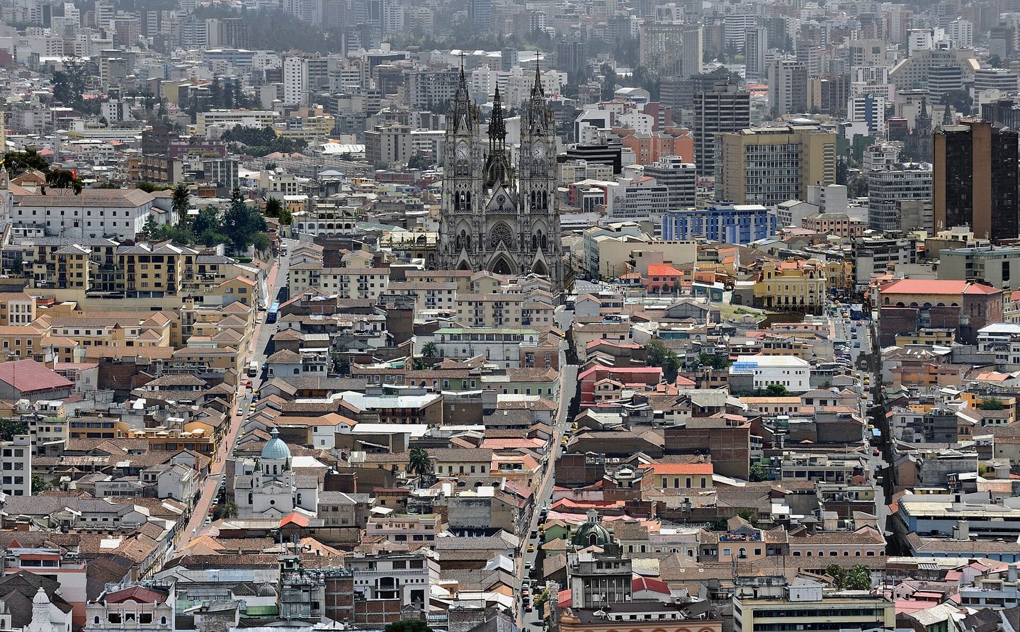
Quito sits at 2,850 metres above sea level on a narrow shelf of the Andes, hemmed by the active volcano Pichincha on one side and a plunge into the Guayllabamba river valley on the other, which is why the city runs thirty-odd kilometres north to south and barely eight kilometres across at its widest. Only La Paz sits higher among the world's capitals. Planes into Quito's Mariscal Sucre airport land at 2,400 metres themselves, out on the plain near Tababela, and the taxi ride into town is itself a small education in how much vertical relief this country packs into short distances.
What that altitude buys the city is a historic centre that UNESCO placed on its very first World Heritage list in 1978, tied with Kraków as the first two cities ever inscribed. Quito's colonial core is the largest and least altered in Latin America after Havana's — thirty-some churches and monasteries, whitewashed facades, wooden balconies, and an entire school of Baroque art and architecture, the Escuela Quiteña, that fused Spanish, Moorish, Flemish and indigenous Andean craftsmanship into something that exists nowhere else. It has survived earthquakes, a 1917 fire, and a few decades of neglect that Quito is still actively reversing, restoration by restoration.
This is not a beach country capital and it does not pretend to be. It is grey more often than warm, cool enough most evenings for a jacket, thin-aired enough that a flight of stairs on day one will remind you what altitude actually means, and close enough to the equator — the line itself runs through the northern edge of the metro area — that sunburn and hypothermia are both live risks in the same afternoon. Get the practicalities right, though, and Quito rewards you with one of the great walkable historic centres anywhere, a new metro that finally makes crossing the city sane, and a base for some of the best day-trip country on the continent: active volcanoes, cloud forest, and a crater lake within two to three hours in every direction.
The caseWhy Quito earns more than a layover
Most itineraries treat Quito as the unavoidable gateway to the Galápagos and nothing more — a night near the airport, maybe a rushed morning at the equator line, then gone. That shortchanges one of the most architecturally intact colonial centres left standing anywhere in the hemisphere. The Centro Histórico covers some 320 hectares of unbroken sixteenth-, seventeenth- and eighteenth-century construction: the Compañía de Jesús church alone carries an interior sheeted almost entirely in gold leaf, and it is one of perhaps a dozen buildings on the continent built to that standard of obsession.
The setting does work no other capital's does. Fourteen or more volcanic peaks are visible from various points around the city on a clear day, Cotopaxi's snow cone chief among them, and Pichincha itself — the volcano the city is built against — is still active enough that it dusted Quito in ash as recently as 1999 and 2002. A cable car climbs partway up its flank in ten minutes flat, which is a genuinely strange sentence to be able to write about a national capital.
There is also the equator itself, which sounds like a novelty until you are standing on it. The line runs through San Antonio de Pichincha, a district within Quito's own metropolitan area, and the monument built there in 1979 has become one of the most photographed spots in the country — with the added, slightly delicious wrinkle that GPS long ago proved the monument itself is planted about 240 metres off the true line, a story that says more about pre-satellite science than it does about the marketing.
Set against Bogotá or Lima, Quito is smaller, more walkable, and considerably less pretentious about being a capital city. Set against Cusco, its obvious rival for colonial-core bragging rights, Quito has more architecture and fewer crowds, because most travellers still fly straight through it toward the islands eight hundred kilometres offshore. That gap between reputation and reality is exactly why a few extra days here pay off.
The calendarWhen to go, and how the altitude changes the packing list
Quito sits close enough to the equator that there is no summer or winter in any conventional sense — day length barely shifts across the year and the temperature band stays remarkably narrow, typically 8 to 22 degrees Celsius (46 to 72 Fahrenheit), cool mornings warming to a bright, thin-aired midday before cloud usually rolls in by afternoon. What changes through the year is rainfall, not temperature, and that is the only seasonal variable worth planning a trip around.
June through September is the driest, sunniest stretch, and also the most popular travel window for exactly that reason — clear skies matter enormously here, both for the view from the TelefériQo and Panecillo and for the ultraviolet exposure, which is worth its own paragraph below. October through May is the wetter season, but 'wet' in Quito rarely means an all-day washout; it usually means a clear, cool morning followed by an hour or two of hard afternoon rain, then clearing again toward evening. Locals half-joke that Quito runs through all four seasons before lunch, and the joke is not far off.
Pack in serious layers regardless of when you land: a base layer, a warm mid layer, and a genuine rain shell, because the swing between a sun-baked plaza at noon and a cold, damp evening is large enough to catch first-timers out repeatedly. Sunscreen is not optional and this is worth taking seriously rather than treating as boilerplate advice — Quito's combination of near-equatorial latitude and thin, high-altitude air routinely pushes the UV index into the extreme range, and it is entirely possible to burn badly on a day that feels cool and overcast. December brings the city's Fiestas de Quito, a boisterous week of parades, bullfighting-adjacent festivities and street parties around the December 6th founding anniversary, which is a great time to be here if you want the city at full volume and a worse one if you wanted quiet museum mornings.
LogisticsGetting around a city that finally has a metro
For most of its modern history Quito's public transport meant the Trolebús and Ecovía lines — electric trolleybus and articulated-bus corridors running the length of the city's main north-south axis, workable but badly overcrowded at rush hour. That changed in December 2023, when Line 1 of the Metro de Quito opened: fifteen stations across roughly 22 kilometres running underground from Quitumbe in the south to El Labrador in the north, cutting a trip that used to eat an hour of surface traffic down to about half that. It is still a single line, so it will not get you everywhere, but it now covers the spine most visitors actually need — connections near the Centro Histórico, La Mariscal and La Carolina are all within reach of a station.
The older BRT network — Trolebús, Ecovía and Metrobús-Q — still fills in the gaps and remains useful for shorter hops, though it gets seriously crowded during rush hours (roughly 7 to 9am and 5 to 7:30pm), when pickpocketing on crowded buses is the main practical risk rather than anything more dramatic. Buy a prepaid card for either system rather than fumbling with coins.
For most visitors, though, ride-hailing apps are simply the sane default. Uber and Cabify both operate reliably in Quito, are metered and fixed-price before you get in, and remove the haggling and safety uncertainty that comes with flagging a street taxi. If you do need a street taxi, insist the driver uses the meter (taxímetro) or agree a fare before moving, and at night book through an app rather than hailing on the street.
Walking is the right way to see the Centro Histórico and La Mariscal, both of which are compact and largely flat by Quito standards, but remember that 'flat by Quito standards' still means noticeably steep, breathless hills once you factor in the altitude — pace yourself more than you would at sea level, especially in the first couple of days. The city is long and narrow enough that a trip from the Centro Histórico to Cumbayá or the airport is a real journey: budget 45 minutes to well over an hour each way to Tababela depending on traffic, and note that this is no longer a quick in-town hop the way the old, since-closed Mariscal Sucre airport used to allow.
The tableHow Quito eats at altitude
Start with locro de papa, because it is the dish that makes the most sense of the climate: a thick, creamy potato soup thickened with cheese, finished with avocado and a side of ají hot sauce, built to be eaten on a grey, cool afternoon, which in Quito is most afternoons. It is Andean in a way that predates the Spanish — potatoes were a staple crop here long before colonisation — and a good bowl of it tells you more about the highlands than most museum visits will.
Hornado is the other essential: a whole pig, marinated in garlic, cumin and achiote and slow-roasted until the skin turns a deep burnished gold, served in thick slices with llapingachos (pan-fried potato-and-cheese patties), mote (hominy corn), and a scoop of curtido — pickled onion and tomato salad. It shows up at weekend markets and dedicated hornado restaurants across the city, and it is worth actively seeking out a busy one rather than the first plate you see, since quality varies enormously and a full house is the best signal.
Ecuadorian ceviche will surprise anyone expecting the Peruvian version: it arrives as a cold, tomato-based broth rather than a citrus-dressed plate, closer to a chilled seafood soup, and comes with popcorn or crunchy plantain chips (chifles) on the side for texture. In the highlands it is usually made with shrimp rather than raw fish, since Quito sits nowhere near the coast.
For drink, canelazo is the city's answer to a cold evening: hot aguardiente sugar-cane spirit mixed with cinnamon and naranjilla juice, sold from street carts especially around the Centro Histórico after dark, and it makes more sense here than any mulled drink does at sea level. Colada morada, a thick spiced purple-corn and fruit drink served with sweet bread shaped like small figures called guaguas de pan, is a specifically Día de los Difuntos (early November) tradition worth timing a trip around if you can. Empanadas de viento — cheese-filled, deep-fried, dusted with sugar — are the everyday street snack, and morocho, a warm, milky spiced corn drink, is the breakfast equivalent of a flat white for a lot of Quiteños. Note the altitude tax on alcohol, too: a beer or a shot of aguardiente hits noticeably harder up here than it would at home, and pacing the first night accordingly is not a myth.
The mapNeighbourhoods to know
Centro Histórico is the colonial core and the reason most people come: Plaza Grande (officially Plaza de la Independencia) ringed by the Palacio de Carondelet, the cathedral and the archbishop's palace, plus the churches of San Francisco, La Compañía and Santo Domingo within a few blocks of each other. It is busy, safe and well-policed by day, roughly 9am to 5 or 6pm, and empties out sharply after that — plan dinner and any evening plans in a different neighbourhood, or take a car directly there and back rather than wandering the Centro's own streets once the shops close.
La Mariscal, north of the Centro, is the backpacker-and-nightlife district built around Plaza Foch, dense with hostels, bars, tour agencies and restaurants catering to visitors. It is genuinely convenient and lively, and it is also the neighbourhood where petty crime — pickpocketing, drink-spiking scams, occasional muggings — concentrates most, specifically late at night around Foch itself. Daytime La Mariscal is fine; treat the small hours with real caution and take a car rather than walk back to a hotel after midnight.
La Floresta, just east and slightly uphill from La Mariscal, is the calmer, more artistic alternative: tree-lined residential streets, independent coffee roasters, galleries and a slower, more local pace, and it is consistently rated one of the safer, more pleasant bases for visitors who want character without the Foch nightlife crowd.
La Carolina, further north, is Quito's big central park — jogging paths, a small lake with paddleboats, a botanical garden and the natural history museum on its edges, ringed by modern high-rises, malls and some of the city's better restaurants. It is safe, comfortable and thoroughly unremarkable architecturally, the trade-off for ease that a capital's business district usually demands.
Cumbayá, in a warmer valley about twenty minutes east of the centre, is where a large share of Quito's wealthier residents and expatriates actually live: a noticeably milder microclimate, shopping malls, a strong café and restaurant scene, and a real sense of having left the cool, grey highland city behind for something closer to spring. It makes an easy half-day trip or a genuinely pleasant, if less central, place to base a longer stay.
Field intelligencePractical intelligence
Altitude first, because it shapes your entire first day whether you plan for it or not. At 2,850 metres, arriving directly from sea level is a real physiological event: breathlessness on stairs, a dull headache, poor sleep the first night, and noticeably reduced tolerance for alcohol are all common and not a sign anything is wrong. Give the first day a light schedule, drink more water than feels necessary, go easy on the first night's drinking, and do not add the TelefériQo's summit trail or a Cotopaxi hike on day one — both climb well above the city's own altitude. Coca or manzanilla tea, offered at plenty of hotels, helps mildly. Anyone with a serious heart or lung condition should talk to a doctor before booking rather than after landing.
Safety is genuinely a matter of area and hour rather than a single verdict on the city. The Centro Histórico, La Floresta, La Carolina and Cumbayá are comfortable with ordinary city caution during the day; La Mariscal is fine by day and requires real care after dark, specifically around Plaza Foch. Do not walk with your phone out on the street, especially on crowded buses or in market crowds, and take an app-booked car rather than a hailed taxi at night anywhere in the city. Street robbery and phone snatching are the dominant risk to visitors, not violent crime in any organised sense, and the mitigation is boring and effective: keep valuables out of sight, don't flash cash, and default to cars after dark.
Currency is genuinely simple by regional standards: Ecuador has used the US dollar as its official currency since 2000, so there is no exchange rate to track and no black-market rate to worry about, though small vendors and taxis often struggle to break large bills, so carry small denominations. Cards are widely accepted in restaurants and hotels in the northern and central districts; markets and street food run on cash.
Tap water is the one clear caution point: Quito's supply is treated but old pipework and inconsistent quality mean bottled or filtered water is the safer default for visitors, including for ice in casual spots. Spanish is essential outside hotels and the more upscale restaurants of La Mariscal and Cumbayá — English is not widely spoken on the street, in markets or with taxi drivers, though Quiteños are patient with a visitor's attempt. Power runs 110V on the same two-flat-pin plugs as the United States, one small mercy of the dollarised, US-oriented infrastructure. And keep a jacket within reach at all times: the temperature swing between a sunny plaza at noon and a cloudy evening is the single most common thing visitors get wrong about what to wear.
Field notesWhat to see & do
-
Basílica del Voto Nacional
The largest neo-Gothic basilica in the Americas, still technically unfinished — local legend holds that finishing it entirely would herald the end of the world, so a few details are always left incomplete. Its gargoyles are carved as Galápagos animals: iguanas, tortoises and condors standing in for Europe's usual grotesques.
On the groundClimb the towers via the narrow stone stairs and exposed metal ladders for a 360-degree view over the Centro Histórico — not for anyone uneasy with heights or tight spaces, and the reward is one of the best views in the city.
-
TelefériQo
A cable car climbing the eastern flank of Pichincha volcano to Cruz Loma at roughly 4,050 metres, one of the higher aerial lifts anywhere, in about ten minutes flat. The summit platform gives a genuine sense of how the entire city sits in a bowl of peaks.
On the groundGo on a clear morning; afternoon cloud regularly closes in and erases the view entirely. Dress for real cold — it is significantly colder up top than in the city, and the thinner air makes even gentle walking noticeably harder.
-
Plaza Grande and the Palacio de Carondelet
The civic and religious heart of the Centro Histórico: the presidential palace, the cathedral, and the archbishop's palace ring a square that has been the city's political stage since colonial times, with the changing of the presidential guard adding occasional ceremony.
On the groundWeekday mornings are calmest; come back at dusk to watch the plaza's evening light hit the surrounding facades before you retreat from the Centro for dinner elsewhere.
-
Iglesia y Convento de San Francisco
Founded in 1535, within weeks of the city's Spanish refoundation, and built over more than 150 years on the site of an earlier Inca structure — the oldest and largest religious complex in the historic centre, nicknamed the 'El Escorial of the New World.'
On the groundThe attached museum sections, easy to skip in a rush, hold some of the finest Escuela Quiteña religious art in the country; budget real time rather than a quick look at the facade.
-
La Compañía de Jesús
A Jesuit church whose interior is sheeted almost entirely in gold leaf, one of the most extravagant Baroque interiors anywhere in the Americas, built up over roughly 160 years by successive generations of Quiteño and European craftsmen.
On the groundPhotography is restricted inside — put the phone away and just look, the interior rewards slow attention more than a photo would capture anyway.
-
El Panecillo and the Virgin of Quito
A hill at the southern edge of the Centro Histórico topped by a roughly 30-metre aluminium statue of a winged, crowned Virgin Mary standing on a dragon, visible from much of the city, with a 360-degree viewpoint over the historic core and the mountains beyond.
On the groundTake a taxi directly to the viewpoint rather than walking up from the Centro — the surrounding streets have a poor safety reputation, while the summit itself is safe and well visited during the day.
-
La Ronda
A narrow, restored colonial street in the Centro Histórico lined with brightly painted facades, flower-hung balconies and small artisan workshops by day, turning into a lively strip of bars and canelazo stalls by evening.
On the groundCome specifically in the early evening, when it shifts from a quiet daytime street into its livelier after-dark version — but treat it as a there-and-back trip by car rather than a jumping-off point for wandering the rest of the Centro at night.
-
Casa del Alabado Museum of Pre-Columbian Art
A restored seventeenth-century colonial house holding more than 5,000 pre-Hispanic archaeological pieces, around 500 on permanent display, presented with real curatorial ambition rather than as a dusty relic collection.
On the groundConsiderably quieter than the churches nearby and easy to have almost to yourself on a weekday — a good counterpoint to an otherwise church-heavy day in the Centro.
-
Mitad del Mundo
The equatorial-line monument at San Antonio de Pichincha, marking the line surveyed by the French Geodesic Mission in 1736 — a 30-metre trapezoidal pyramid, a small model town, and the museums and rituals built up around straddling both hemispheres at once.
On the groundModern GPS shows the actual equator runs about 240 metres from the monument's painted line; the nearby Intiñan Solar Museum claims to sit on the true line (though even that is disputed by a smaller margin) and runs livelier, hands-on demonstrations — visit both rather than picking one.
On the groundWhere things are
Map data © OpenStreetMap contributors.
Where to stayBase yourself well
Centro Histórico
Best for first-timers focused on the historic sights and colonial architectureThe colonial core itself — churches, plazas and restored mansions turned boutique hotels, with almost every major historic sight within a ten-minute walk. Busy and safe by day, and considerably quieter at night, which suits some travellers and not others.
A restored colonial mansion hotel near Plaza Grande
Several former republican-era houses in the Centro have been converted into boutique hotels with interior courtyards — a genuinely atmospheric base, with the trade-off that the surrounding streets go quiet early.
€€€A budget guesthouse near San Francisco Plaza
Simple, central, and steps from the Centro's major churches; arrange evening transport in advance since taxis are harder to hail on the Centro's streets after dark.
€La Mariscal
Best for budget travellers, solo backpackers and anyone prioritising nightlife and tour-booking convenienceThe backpacker and nightlife hub around Plaza Foch — dense with hostels, tour operators, bars and restaurants geared toward visitors. Convenient and social, with a late-night safety reputation that requires real care.
A hostel a block or two off Plaza Foch itself
Being just off the square rather than directly on it trades a little nightlife noise for a calmer night's sleep without losing the walkable convenience.
€A mid-range hotel toward the quieter northern edge of La Mariscal
The blocks nearer La Carolina keep the neighbourhood's restaurant access while stepping back from the Foch late-night crowd.
€€La Floresta
Best for travellers who want character and a slower pace without La Mariscal's nightlife churnA calmer, artier alternative just uphill from La Mariscal — independent coffee roasters, galleries and tree-lined residential streets, consistently rated among the more pleasant and secure areas for visitors.
A small design-led guesthouse in La Floresta's residential core
Close enough to La Mariscal's restaurants to walk, far enough to sleep through the noise.
€€La Carolina
Best for business trips and travellers who want ease and modern conveniences over historic atmosphereThe modern, business-district north — high-rises, malls, the city's big central park, and a strong cluster of contemporary restaurants. Comfortable and safe, if architecturally interchangeable with any large Latin American capital's business zone.
An international-standard hotel facing Parque La Carolina
Reliable, well connected to the new metro line, and a short walk from the park's running paths and weekend market stalls.
€€€Cumbayá
Best for longer stays, families, and anyone who wants a break from the cool, grey highland climate of the centreA warmer valley suburb about twenty minutes east of the centre, popular with expatriates and wealthier Quiteños, with a noticeably milder microclimate, shopping malls and a strong independent café and restaurant scene.
A boutique hotel or serviced apartment near Cumbayá's main plaza
You trade proximity to the historic sights for genuinely better weather and a slower, more residential pace — worth it on a stay of five days or more.
€€Affiliate notePostcardRoute is reader-supported. Some links to accommodation are affiliate links: if you book through them we may earn a small commission at no extra cost to you. We only recommend places we would send a friend.
Beyond the cityWorthwhile day trips
- Otavalo Market
About two hours north, one of the largest and longest-running indigenous markets in South America, run by the Kichwa Otavaleño people and famous for textiles, weavings and leather goods, alongside a separate animal market that starts at dawn. Saturday is the biggest and busiest day; a weekday visit trades scale for a calmer, more browsable experience.
- Cotopaxi National Park
Roughly ninety minutes to two hours south, home to one of the world's highest continuously active volcanoes, its near-perfect snow-capped cone visible from Quito itself on a clear day. Most day visits stop at Laguna Limpiopungo for an easy high-altitude walk with the volcano as backdrop rather than attempting the summit, which requires technical mountaineering experience.
- Mindo Cloud Forest
About two hours northwest, dropping from the cool highlands into warm, biodiverse cloud forest — serious birdwatching (hundreds of species, including numerous hummingbirds), butterfly farms, chocolate tours built around locally grown cacao, and zip-lining through the canopy for those who want more adrenaline than binoculars.
- Quilotoa
A three- to three-and-a-half-hour drive south, a water-filled volcanic crater with a startling turquoise-green lake far below the rim. The full crater-rim hike is a serious half-day undertaking at altitude; most day-trippers instead take the shorter path down to the water's edge and ride a mule back up.
Before you goCommon questions
- How many days do you need in Quito?
- Two full days cover the Centro Histórico's churches and plazas plus the Panecillo or TelefériQo at a comfortable pace. Three or four lets you add a day trip — Otavalo, Cotopaxi or Mindo are all feasible as a single long day — without rushing the city itself. Most visitors are here as a Galápagos or Andes gateway, but the historic centre alone rewards at least two unhurried days.
- Will the altitude in Quito make me sick?
- Most visitors feel something without being seriously ill: breathlessness on stairs, a mild headache, disrupted sleep the first night, and noticeably lower alcohol tolerance. Keep the first day light, drink more water than feels necessary, avoid heavy drinking the first night, and don't add the TelefériQo's summit trail or a Cotopaxi hike to day one, since both climb well above the city's own 2,850 metres. Anyone with a significant heart or lung condition should check with a doctor before booking.
- Is Quito safe for tourists?
- It varies by area and hour more than it does by any single citywide verdict. The Centro Histórico, La Floresta, La Carolina and Cumbayá are comfortable with ordinary caution during the day; La Mariscal is fine by day and needs real care at night, particularly around Plaza Foch. Street robbery and phone snatching are the main risks, not organised violent crime — avoid walking with your phone out, and take an app-booked car rather than a hailed taxi after dark anywhere in the city.
- Where is the actual equator in Quito, and is the monument accurate?
- The Mitad del Mundo monument at San Antonio de Pichincha marks the line surveyed by the French Geodesic Mission in 1736, but modern GPS measurements show the true equator runs roughly 240 metres away from the monument's painted line. The nearby Intiñan Solar Museum claims to sit on the actual equator and offers livelier hands-on demonstrations, though even that site is understood to be off by a smaller margin. Visiting both, rather than treating one as definitive, is the honest way to do it.
- What currency does Quito use, and is it easy to pay for things?
- The US dollar, Ecuador's official currency since 2000, so there is no exchange rate to track. Cards are widely accepted in restaurants and hotels in the central and northern districts, but carry smaller bills for taxis, markets and street food, since vendors often cannot break large notes.
- What is the best time of year to visit Quito?
- June through September is the driest, sunniest stretch and the most popular travel window, especially for views from the TelefériQo and Panecillo. October through May brings more rain, usually as a predictable afternoon downpour after a clear morning rather than an all-day washout. Temperatures barely change across the year regardless of season — pack layers and a rain shell either way.
- Can I drink the tap water in Quito?
- It is treated but old pipework and inconsistent quality mean bottled or filtered water is the safer default for visitors, including for ice in casual restaurants and street stalls. Use it for cooking and brushing your teeth without concern; drink bottled for everything else.